Where do you live?
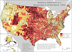
I came across this map today from the 2000 census stats, it caught my interest for a minute or two. I’ve lived in all four of the different ranges at some point or my life or another. Some of the other things that I noticed include:
- The large white areas in Oregon, Maine, Northern Michigan, Northern Arizona, Ohio, and West Virginia. Northern California didn’t surprise me that much.
- The oddity of counties being extreme opposites next to each other. Like the one white spot in North and South Dakota, is that Tom Daschle’s house?
- Mormons live in one spot
I’d like to see this map overlaid with some other maps including voter registration and voting results maps. I’d also like to see what it would have looked like at certain points between then and now. I bet you would see some spikes at certain times (ie. September 11th and Katrina/Rita devastation). I know our church grew for a while after each of those events before slowly starting to taper off. Other ones that would be interesting to me to compare them to would be previous decades and maybe a current day version.
Who knows, maybe you won’t spend as much time thinking about it as I did…

Click the image for a larger version
Very interesting! You sure can see that bible belt can’t you?!
too bad about Michigan……… and what’s up with that blob in western Alaska??